Part of it is imports. The first sidewalk import happened in Heidelberg, Germany, but it focused on sidewalk=* tags for consistency with existing tagging in the area. Within about a year, various members of the U.S. community began a wave of sidewalk imports that added ways, starting with Seattle; Washington Court House, Ohio; and San José, California. The San José import alone added some 3,409 miles (5 486 km) of sidewalks, which we manually connected with more than 175 miles (282 km) of crosswalks.
(Ironically, for all the angst we saw about sidewalk ways, we actually had to do nontrivial work to have linear geometries, because the City of San José only provided polygons. Who knows, maybe we’ll go back and add in all the area:highway=footways we’ve been sitting on for the last eight years. We still have an opportunity to outpace Google Maps right in their backyard. So far they only show sidewalk areas in a few smaller cities like San Francisco. )
Regardless, as these charts show, there’s been a lot of organic growth too. It’s only natural to want to draw something you can plainly see on the map. Tags on the roadway are apparently less intuitive to many mappers.
By the way, the query I shared distinguished sidewalk=separate/no and sidewalk:left/right/both=separate/no from other values. I think this should account for mappers who only use these keys to indicate the existence or nonexistence of separate ways. sidewalk=lane is one of the proposed tags for pedestrian lanes, but those are relatively rare in the U.S. anyways.
In my understanding, any sidewalk is nothing but a lane of a street. Quote from local traffic code:
Gehsteig (sidewalk): ein für den Fußgängerverkehr bestimmter, von der Fahrbahn durch Randsteine, Bodenmarkierungen oder dgl. abgegrenzter Teil der Straße;
Gehweg (walkway): ein für den Fußgängerverkehr bestimmter und als solcher gekennzeichneter Weg;
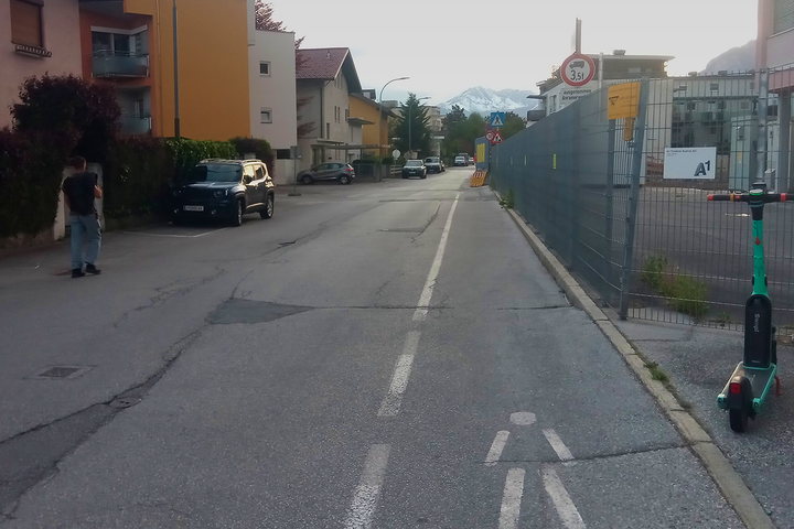
Unlike other lanes, these (more and more often) mapped separately. Purely separated by paint exists, and gets mapped separately too. (Unlike the picture suggests, these are mandatory in use.)
I would suggest the same to you that I did to my fellow American. A simple painted line isn’t physical separation; mapping a separate way unnecessarily confounds pedestrian routing. highway=sidewalkfootway=sidewalk is how you indicate that a walkway runs alongside a street as an accessory to it. It denotes a physical configuration or design, not a legal designation. If you need to encode a different legal distinction, we have other tags for that, such as designation=* and access=*. (The sign pictured is an access sign according to the Vienna Convention.)
When tagging the presence of a pedestrian lane on a roadway, I favor footway=lane over sidewalk=lane, but sidewalk=lane is more popular by raw element count. The wiki already discusses the competing ideas in detail.
Nevertheless, if you can demonstrate that pedestrian lanes are intentionally being mapped as separate ways and tagged as sidewalks in statistically significant numbers, and that sidewalks are intentionally being tagged as independent footpaths in statistically significant numbers in the same region, we should document that to warn renderers and routers and to satisfy the needs of:
By all accounts, you could very much map (exclusive) cycle lanes as separate lanes or even a single carriageway into two directions if overtaking is forbidden. We don’t do this because it violates the One feature, one OSM element rule and Dual Carriageway guideline: One carriageway, as long as it isn’t separated by a hard barrier, is one element.
If the footway is flush with the carriageway (or moreso if it is part of the carriageway), it’s basically part of it regardless how they’re classified by the local laws.
Mind you, that in my world, mapping a sidewalk separated from the carriageway merely by a kerb also violates the one feature rule, because any sidewalk is but a lane of a street. I guess I am the only one here that understands the term street to mean a shared public space. A street is not just the carriageway, streets are not for the motorists only. Sometimes this saddens me a bit, because the separation of lanes by mode runs contrary to efforts to make towns more friendly to pedestrians by strengthening their rights instead of forcing them out of the way of motorists.
I certainly won’t ever map such a sidewalk as pictured above, where only ground markings separate the pedestrian area from the carriageway (NO, the sidewalk there is NOT part of the carriageway) as a separate footway. Others do. But who am I to tell them, that they are doing it wrong when they do? Making bold claims in the forum is not the same as confronting mappers with changeset comments eg.
In the linked document it is under Section D, Mandatory Signs, Section II point 5, short Sign D, 5. I am just pondering the correct OSM mapping of what picture shows, the tags relevant here:
highway=footway;footway=sidewalk;foot=designated on the sidewalk and sidewalk=separate;foot=use_sidepath on the street perhaps? foot=no on the street certainly wrong; Though I have seen that too, perhaps to make some stupid consumers force into using the separate footway?
We need to be careful about OSM keywords versus the words we use in natural language. Regardless of which English definition of “street” you hold in high esteem, or however you choose to translate legal definitions in any language, keywords like highway and sidewalk have a particular meaning that many other tags are tied to. The agreed-upon purpose of sidewalk=* and footway=sidewalk is to refer to a particular physically separated form of pedestrian infrastructure so that data consumers can distinguish it from other forms.
We cannot realistically point to the definition of a street in a chapter of the California Streets and Highways Code to determine whether a data consumer should expect one way or three, any more than we can expect this same legal code to determine that all highway=service ways should be tagged service=driveway because it makes no provision for McDonald’s drive-throughs (or else driveway2 because driveway has supposedly been unlawfully redefined by us). To the extent that the legal definitions align with how laypeople refer to things in the local language, we may need to improve software localizations to produce less confusion.
This does not mean we value cars over pedestrians. Quite the contrary: by maintaining a dependable definition of footway=sidewalk that does not require a subscription to a legal database, we open up possibilities for data consumers to serve pedestrians without guesswork. The distinction you seek can be implemented through explicitly legally relevant tags, designation=sidewalk or designation=Gehsteig if you like; by tagging the effective access restrictions; by mapping a landuse=highway around the street’s entire right of way; and by mapping individual traffic signs.
Is it so bold? I’ve pointed to consensus through the tag approval process and imports that have added more sidewalks than you or I will ever map manually in our lifetimes. You may want to demonstrate that a significant number of mappers or data consumers interpret the tag otherwise, or that a significant share of footway=sidewalk usage indicates otherwise. Then we can have a constructive conversation about how to resolve or accommodate the misunderstanding.
Yes, this matches my understanding of how the pictured sign affects OSM tagging for an already separate sidewalk way. use_sidepath should have decent support as effectively a synonym for no when a sidewalk runs parallel to the roadway.
If there is a cycleway=lane, then there is footway=lane, the same method or a shared_lane, method choice in OSM, if both looks the same, only difference is the symbol. Then we should use the same methode.
Uh, and what it would need to separated with to qualify as separately mapped sidewalk in your world? Bollard row? Jersey barrier? Hedge barrier? Tree row? Fuel station? Building block? Something else?
Or do you denounce separately mapped sidewalks in any shape and form anywhere on the map (or in your location only)?
Well, that claim is heavily disputed, if you’d care to reread the thread. Not everyone lives in one specific region, and traffic codes across the world differ, sometimes wildly.
To draw a parallel, just because one might be “…the only one that understands some water area is called Gulf of America” does not necessarily make the rest of the world agree. (Feel free to replace “America” with “Mexico” above if that makes the claim less palatable, to drive the point home ).
Definitely… And while I could tell a lot of sad stories too, or point to Roads Were Not Built for Cars, I’d prefer to stick to OSM mapping issues in this forum.
This whole thread however raises some nagging question in my mind: “Why does it matter?”
I mean, why does it matter for data consumer (and not why stroking the ego of the mapper always matter to the said mapper, which is rather clear)?
In other words, how would data consumer change their behaviour depending whether something is tagged:
just as highway=footway way going parallel to the highway=primary (i.e. if that is “just” a footway or footpath or whatever you want to call it, but not a sidewalk)
as opposed it if was tagged as:
highway=footway + footway=sidewalk way going parallel to the same highway=primary (i.e. if it is “an actual sidewalk” or whatever you want to call it)
In other words, if someone really stole that sign from the picture at the bottom of that post, how would pedestrians (or cyclists, or motorist etc) behave differently?
Are there different rules? Can those rules be expressed with different OSM tags if one didn’t want to read to 168+ posts of this thread (e.g. just random example to show what I mean – maybe with sign it is bicycle=yes, but without it is bicycle=no)?
Additionally, what would be the practical difference to data consumer between second example above ( highway=footway + footway=sidewalk parallel to highway=primary), and the situation when there was onlyhighway=primary with extra tag sidewalk:left=yes (but without any other way tagged parallel to it)?
Please add your jurisdiction when providing comments, thanks!
Footways and pavements (sidewalks) are legally distinct concepts, but in all aspects equal from the perspective of all road users.
There is a legal difference in some cities that have regulations that mandate snow clearing by property owners from pavements (and only pavements).
Practical
Signed footways practically don’t exist. I know of two off the top of my head in the entire region.
Unsigned footways are far more common. The unsigned footways are typically recreational paths or random strips of paved way serving as shortcuts between adjacent residental streets.
Pavements are always paved. Recreational paths are commonly gravel.
If this way were tagged footway=sidewalk, I would know it’s paved. As it stands, I couldn’t be certain if someone hadn’t added surface=*.
A pavement is far more likely to require you to traverse a high kerb to get anywhere.
Being able to move “freely” from a footway to a parallel carriageway (for crossing or something) is less likely – there’s almost always some sort of drainage ditch or something else in between that makes that less attractive. This is not to say that high kerbs are not a barrier, but crossing a 1.5 m wide drainage ditch or two high kerbs in short succession is perhaps even worse.
Data consumers
I think for data consumers the difference between the highway=footway and footway=sidewalk/sidewalk:left=yes would boil down to the practical differences above.
footway=sidewalk and sidewalk:left=yes would be identical from a local perspective. If you also care about the street the pavement is “on” (which some people argue strongly that they do), there’s a difference, but I think this would apply globally.
There is no legal concept for ”sidewalk” that would be different from ”footway”. The term ”jalkakäytävä” is defined as ”a physically separated part of a road, intended for pedestrians; or a separate road”.
The way in the picture would be a footway (bicycles ok only for children) regardless of the sign (it would need a cycleway sign to generally allow cycling). I can’t think of any practical difference between highway=footway (with or without footway=sidewalk) and sidewalk:left=yes, beyond the extra info that could be tagged or drawn on the separately drawn way.
Finland has a similar snow clearing law as Norway, but without distinction between sidewalk and footway. The speed limit on a footway or a cycleway is theoretically determined differently depending on if there’s an associated carriageway or not, but I can’t really see practical relevance there either.
Basically every road must have carriageway
it can have a sidewalk and then people have to walk it, can’t walk on a side of carriageway.
vehicles can’t ride such a sidewalk,
which of course is also no different than a footway
But default access value for em in unknown for bikes and rightfully, because here you can ride a bicycle there if allowed speed on carriageway is above 50km/h.
So marking it a sidewalk can in theory help routings if speed is set for the carriageway.
Every road is actually an area, which by definition includes everything on it… so easy to say if it;s a sidewalk, because it is only when inside that legally specified area.
But if there is an intersection… it’s not really that easy to say of which road the sidewalk is part of.
I believe that setting a footway as a sidewalk is specifically for our whim and not actual usefullness. Because for the routings to know which road that sidewalk is part of and therefore is actually one, we’d have to use street relation. Because that’s the only way for routings to know it without a gueswork.
But my gues is that people prefere to use a bunch of easy to set tags, rather than use relations, coz those are not that easy to map and maintain.
So we choose faulty mapping over more time consuming one, coz we don’t have good tools to make it easy.
This is bad of course, but there are already nearly 200 posts here because likely people see issues, but don’t know how to pinpoint em, so problem is selfexplanatory and people can stop asking questions?
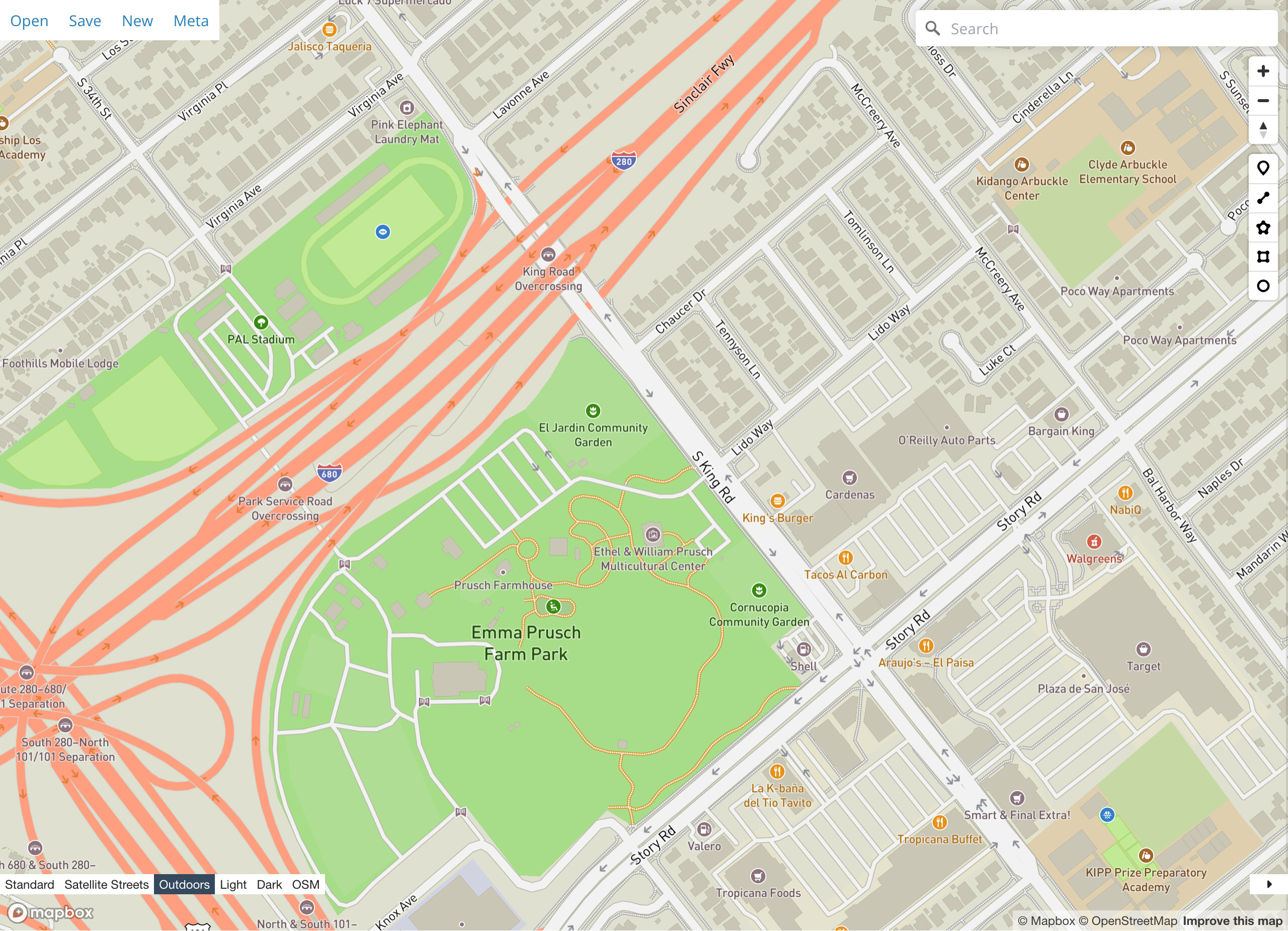
The proposal for separate sidewalk ways envisioned that renderers would depict sidewalks differently than other highway=footways, for example by hiding sidewalks until higher zoom levels where they wouldn’t add so much noise to the map. Although OSM Carto has yet to implement this heuristic, some third-party styles do noticeably deemphasize sidewalks relative to independent walkways.
For example, if you navigate to this park in geojson.io and switch between Mapbox’s Outdoors style and “OSM” (OSM Carto) using the control in the lower-left corner, you can see just how much visual noise this heuristic removes from the residential neighborhoods – something designers care a lot about – while retaining the park paths with the prominence they deserve.[1]OpenTrailStash implements a similar effect, making sidewalks blend in with the roads at a glance. OpenTrailMap intentionally highlights walkways other than sidewalks as walking destinations.
Beyond rendering, some routers tailor their behavior to sidewalks or the lack thereof. For example, Valhalla has a built-in costing option that allows the application to favor or avoid sidewalks. This is separate from the option for favoring or avoiding walkways in general. Ideally, Valhalla would also vary its pedestrian guidance instructions to refer to “the sidewalk” instead of “the walkway”, just as it instructs the user to use “the crosswalk” when it encounters highway=footwayfootway=crossing. Judging from this discussion, Valhalla’s German Standard German localization would need to exercise care around terms such as Gehsteig and Gehweg. (Currently, it translates “walkway” as Fußweg.) As mentioned earlier, a navigation system could also use this information to decide when to infer street names from nearby streets using map matching.
So, I guess I disagree with this conclusion. Granted, we could be documenting these use cases more thoughtfully so the tag doesn’t seem as arbitrary.
Mapbox’s car-centric Standard style deemphasizes all pedestrian infrastructure. After all, by the time it debuted, Mapbox already came to think of itself as an automotive platform. ↩︎
Use case: pedestrian route relations
I create, maintain, and use many pedestrian route relations. Often, it doesn’t matter where on the road you walk, and whether there is a sidewalk or not, but many times it does. Where it matters, I want the sidewalk or side path to be rendered and I want the route line to show on the sidewalk / side path.
So, when mapping a pedestrian route, I map separate ways where I feel that a walking route should pick a side. For wheelchairs, blind people and the like, picking the exact way is even more important, and especially in urban environment I tend to cater for e.g. tactile paving and lowered kerbs by adding explicit footways.
Since route relations are ‘frozen’ routing results, I think routing and navigation software has similar issues and considerations in pedestrian and disabled modes.
Physical separation
Note that the type of physical separation does not matter for this use case. The physical separation criterion (as opposed to “just” lines) is not adequate for the extreme variablity of sidewalks/side paths. In my village, it would require sidewalks/sidepaths to be cut into a multitude of sections.
Now I am all for detailed mapping, but this is one bridge too far. If most of a stretch of sidewalk is separated from the carriageway by a kerb and it is part of a route relation where I feel that side matters, I draw the separate way, including the shorter sections where there is a line instead of a kerb.
Physical separation is admittedly an imperfect heuristic, but the same is true when applied to roadways too. Most mappers will map a dual carriageway straight through an intersection, forming an H, even if technically the median ends some short distance from the intersection due to a turn lane. There are also gray areas where drivers are technically allowed to cross a median at arbitrary points for certain purposes. There’s still disagreement about whether to account for stretches of road that are divided by alternating medians and center lanes, resulting in a sausage link effect in some renderers and incessant fork instructions in some routers, but also allowing us to faithfully micromap the medians. Still, by and large, the heuristic works for the vast majority of situations.
Route relations are a tricky case. I’ve mapped plenty of route relations for cycling and hiking routes that don’t officially distinguish the roadway from the sidewalk, especially if the sidewalk is built after the route is established. This sometimes causes confusion among mappers who, as motorists, assume the roads are for them and them alone.
Conversely, I’ve mapped many routes that expect cyclists or hikers to hug the bike lane, shoulder, or verge of a busy road. (Thankfully, many have since been upgraded to have proper cycling infrastructure.) In these cases, I relied on the way’s tags to communicate that non-motorists need to avoid the traffic lanes. Mapping a separate cycleway would’ve papered over the risk of following these notorious gaps in the trail. These days, as cycling advocates often rely on OSM, an idealized representation would make it more difficult for trail users to advocate for improvements.
For now on topic of sidewalks, have adopted the vrs mentioned street:name tag for future data consumers and not to create this cacaphony of names on maps. Still include them in type=street relation, future role of course ‘sidewalk’ ;o)
… back to the main course of understanding the wiki.
No idea what to quote, can only repeat: We have a legal term that literally translates to sidewalk and that includes those pedestrian lanes as you call them. This legal term is deeply entrenched in local mappers, it is a colloquially accepted term. I cannot fault mappers for mapping a separate way where you only see a pedestrian lane, because here it is not about marking or kerb, it is about separation only. They are doing what they are told: To map sidewalks as separate ways. I propose: highway=footway;footway=sidewalk;sidewalk=lane (incremental enhancement.)
One thing I am still uncertain about: Do you actually propose that consumers should not route over bare highway=residential, because that means, that this is only for vehicles and pedestrians forbidden? Shouldn’t openstreetmap then rename itself to opencarriageway?