Understanding the wiki page on sidewalk

Rest assured, I am proposing no such thing. Routers will route over whatever achieves the best result, for some definition of “best” that suits their audience and use case. There isn’t only one right answer. In order to accommodate a diverse array of data consumers, some tags need to form an answer to the question “What is it?” with a degree of certainty.

To reiterate, a sidewalk is not merely an abstract legal concept, but rather a real-world object that some data consumers need to distinguish reliably. It is only by coincidence that American English has a convenient word for this concept, so that’s what we used instead of footway or pavement. The law has little to do with it.

Maybe you followed my earlier link and discovered that California, too, officially defines “street” to include the entire street right of way, via the Tree Planting Act of 1931:

“Street” means all or any portion of territory within a city set apart and designated for the use of the public as a thoroughfare for travel, and includes the sidewalks, the center and the side plots thereof.

Fortunately, the act’s authors were wise enough to limit the law’s application to certain activities that the government has an interest in:

This part provides an alternative system for the planting, maintaining or removing of trees in cities, and the provisions of this part shall not apply to or affect any other provisions of this code.

I’m even less qualified to interpret Austrian law than American law, but I couldn’t help but notice the preface to the list of definitions in the Austrian StVO:

Im Sinne dieses Bundesgesetzes gilt als
[Within the meaning of this Federal Act]

In other words, your government graciously permits you to utter the word Gehsteig in connection with sidewalks, without applying this word to everything the StVO would call Gehsteig and even some things the StVO would call a Gehweg. You could even surround it in „quotation marks“ for dramatic effect, as I often do with the weird term “trunk road”. But if this is too counterintuitive, you could coin a different word for the concept of a street’s physically separated accessory walkway. German has a prodigious ability to form new compound words.

Every language community in OSM has had to navigate a semantic minefield in order to craft a usable tagging scheme. For example, in English, we eventually settled on “traffic park” as the best alternative to a circumlocution so long that @Mateusz_Konieczny could’ve copyrighted it. But you don’t see anyone campaigning to move the tag to leisure=park park=traffic. Everyone knows what a “zebra crossing” is, right? In the U.S., a zebra crossing is officially defined as having slanted bars, or else it isn’t a zebra crossing. Yet we have acquiesced to a definition of crossing:markings=zebra that specifies straight bars for the benefit of Europeans. You’re welcome!

Is it really the case that your fellow mappers are so dependent on pronouncements of law that you wait to hear back from the local authority before deciding whether to map something as a separate way? How is that degree of deference beneficial to OSM? Can I be sure I’m debating against a sincere local consensus, the result of trying and failing to bridge the language divide through user education or better software localization?
2 Likes

This was an enlightening list, thank you. One thing that strikes me is, multiple people are saying that footways which are not associated with a road are more uncommon than, let’s say ”de facto sidewalks”. Your list of data consumers care about these more uncommon ways (and I’d guess some of them really aren’t even intended for urban areas).

So is it them right to say, that people mapping footways in urban areas should be specifying them as sidewalks for the benefit of consumers that don’t want to render them? Or are there also data consumers who specifically want to use sidewalks, rather than just hide them? I think that kind of an example would be more motivational for mappers (in areas where local law doesn’t make this distinction meaningful).

For what it’s worth, I don’t think OpenTrailMap’s use case can expect to produce a render that is free of false positives in an urban setting (as demonstrated when zooming out from your link).

OpenTrailStash and the Outdoors style are much better examples, IMHO, as they produce a nice render for the kind of area where sidewalks actually occur. And at least in OpenTrailStash’s case are actually intended to be used there.

Yes, I screenshotted a park nestled in a vast expanse of urban sprawl within my city in order to highlight the contrast between sidewalks and other walkways, but these three renderers are oriented toward outdoor activities wherever they occur.

Put simply, footway=sidewalk is a functional classification. In OSM, we don’t question the need for highway=trunk versus primary versus secondary versus tertiary versus unclassified versus residential versus living_street versus service, even in the absence of legal classifications. Most renderers distinguish these classifications with all the colors of the rainbow; it isn’t far-fetched to imagine a renderer that promotes walkways by efficiency.

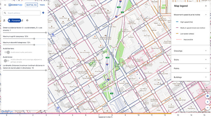
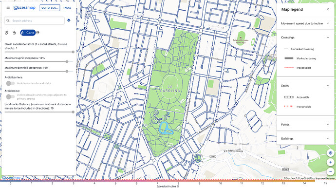
The first one that comes to mind is AccessMap, which provides flexible rendering and routing for several different underserved profiles, such as riding a mobility scooter around Seattle or walking with a cane in Quito. The intended user would seek out uniform, higher-quality pedestrian infrastructure, so AccessMap draws sidewalks more prominently than other walkways as a useful generalization. @UW_Amy_Bordenave would be more knowledgeable about this application.

The other maps aren’t completely hiding sidewalks. They just treat them as an additional level of detail, as micromapping, just as car-centric maps deemphasize service roads, especially parking aisles and driveways, until the highest zoom levels.

2 Likes

While I get what you mean, I’d argue that it’s mostly a limitation by OSM[1] where the highway is typically seen from the perspective of the carriageway (or two carriageways where applicable), though it hardly only affects footways because… just about every parallel way you can think of (most classic example are cycle tracks and certain busways).
Heck, even a (non-busway) carriageway can be just a sidepath to another carriageway (I’m not meaning frontage roads but cases where a lane is split by a barrier)![2]

This also makes the suggestion of sidewalk=lane on a footway=sidewalk controversial (except maybe for transitional pieces) and should be treated as deprecated because it also opens up to do the same for cycle and bus lanes (and the aforementioned treating roads where overtaking is forbidden as dual carriageways which might be true from a legal standpoint but certainly not on OSM).

The other reason is from a user’s perspective: If the carriageway, footway and cycleway are all flush (if not sharing the surface but still clearly marked), it means it makes it easier to change from one lane to another (aka why most cycle lanes are dangerous). This affects wheelchair users in particular because it means they can cross the carriageway just… everywhere wherever they want instead of at dedicated crossings where the kerb happens to be lowered[3] (this is also why I consider @Peter_Elderson’s method controversial alongside the fact that it results in inconsistent sidepath mapping which I’m never a fan of).


  1. Which has been accused of being too car centric, for that matter ↩︎

  2. Slip lanes are arguable such as case but it also includes collectors in cloverleaves, bus bay ways and even the odd tram stop where one lane is raised to provide level boarding for the passengers. ↩︎

  3. Or they travel on the carriageway when that’s too impractical ↩︎

then ideally translations of OSM presets would have a bit longer name noting or explaining the difference

(there are other cases of seemingly matching terms not actually matching or false friends of various kinds - in various languages and dialects)

1 Like

Tagging a separately mapped way as a lane is the (so far only) proposal to solve this problem.

(Dare I mention village green? Better not.)

1 Like

I put it to you that “trunk cycleway” / cycleway=expressway / whatever are also a functional classification, but we do question that in absence of legal classifications :slight_smile:

But not to derail the topic, I’m approaching this as someone who mainly maps things I personally find useful. E.g. missing surface tags or missing ways. I have a degree of empathy for other users’ needs, but I’m not going to spend my time mapping for mapping’s sake. Basically, I’m seconding Yog_Sot’s “actual usefulness” comment.

I would contest quality/accessibility as a valid reason to tag sidewalks in general, because sidewalk does not make any claims about quality or accessibility (e.g. wiki specifically talks about “abled individual”, has photo of a sidewalk with steps etc.). And there are more specific tags available, that are more directly useful.

Locally, the vast majority of pedestrian ways here are twoway non-segregated shared cycleway/footways, which as a rule are wide and have lowered kerbs. Smaller residential roads have no infrastructure. Normal sidewalks (kerb, no bicycles) are rare.

The main feature they have in common is that they’re too narrow to allow bicycles, and possibly have trees growing in the middle etc. Point being, they’re fine to walk on but I can’t think of a reason anyone would actively want to be routed on them specifically. Especially if they have any kind of accessibility needs.

I would never call “my method” a method! It’s more of a guiding idea, in the face of an abundance of valid options and utter inconsistency in mapping methods present in the OSM database. I think it adds consistency, just not in terms of hard definitions and “it has to be the same everywhere”.

Of course, anyone can cross wherever they want, if it’s allowed. If lowered kerbs are not an item for wheelchair users, fine, I maybe they are meant for a different user group, in which case wheelchair routing will probably ignore them, or offer an option whether or not to stick to lowered kerb routes. Still, tactile paving and lowered kerbs are meant for users of pedestrian infrastructure, so it makes sense to me to micromap them together with the footways.

Maybe I misunderstood you but I mostly refers to this part:

This to me reads like you’d map a way regardless whether there is a physical separation or not.
Maybe it only refers to short stretches in which case that’s more of a valid use-case (kind of like having a cycleway still a separate way despite shortly becoming a lane at crossings).

In general I stick to the “physical separation rule”, unless it leads to silly subsections or awkward routes. The more detailed I map, the more situations I encounter where the physical separation is less important than the function of the separation.

3 Likes

In the absence of more detailed tags, routers always have to make generalizations. I need only utter the word path to make that point. There have been many well-intentioned pleas for data consumers to completely ignore ways that lack surface=*, width=*, or tracktype=* tags, but notably these pleas only come from mappers seeking to influence the tagging scheme or motivate other mappers, rather than from end users trying to go about their business, so of course those pleas go unheeded.

(The photo of sidewalk steps is intended to demonstrate a case that sidewalk=* on the roadway cannot adequately express. For that matter, neither can footway=sidewalk, because the steps would be tagged highway=steps. But the point stands that tags aren’t a very effective tool for encoding topology.)

AccessMap is actually a rare data consumer that accounts for obstacles within the sidewalk. In Quito, for example, it marks the location of each utility pole that obstructs the sidewalk, helping users find alternative routes. AccessMap also demonstrates that accessibility is not just about standard wheelchairs. It shows certain sidewalks if the user says they’re walking with a cane – either vision-impaired or elderly – but not if they’re riding a wheelchair or mobility scooter.

Anyways, I don’t think anyone is arguing that sidewalk ways are only valuable if they are tagged as footway=sidewalk. I very frequently encounter sidewalks with nothing but highway=footway, mapped either by an inexperienced mapper who hadn’t come across the Sidewalk preset or by a long-standing mapper before footway=sidewalk was approved. My response is to add footway=sidewalk to the sidewalk and sidewalk:both=separate for the roadway, not to delete the sidewalk.

4 Likes

Thanks @Minh_Nguyen for the AccessMap shoutout :slight_smile:


I’d like to steer this thread back in the direction of focusing on the Wiki - ideally, the outcome of this would be a revamp of the documentation on the Wiki of the mapping of pedestrian infrastructure in OSM.

There’ll be the PWG’s Schema and Guide, and we (TCAT) have our own closely-related OpenSidewalks Schema and mapping guides, but the main OSM Wiki pages definitely need some TLC.

Depending on what you use to estimate it, the Sidewalks page itself is a 20-30+ minute read, and that’s not including any related pages that directly or indirectly mention sidewalks and urban paths.

Despite making a fair number of edits to the OSM Wiki, I don’t have nearly the experience that some others in this community do with Wiki work - @Minh_Nguyen are you familiar with WikiProject-style organized Wiki updates? Would that type of management be appropriate here?

1 Like

This is a feature description page, not really a WikiProject page, but it reads more like meeting minutes. A lot of the verbiage is devoted to the debate about tagging sidewalks on roadways versus mapping separate ways. You can see the facts and arguments laid out for both sides but comparatively little guidance for mappers or data consumers trying to accomplish their tasks. Maybe this has the result of overselling the controversy, making it seem like more of an issue than it really is these days.

But before we tackle that, I think a good first step would be to split out an article devoted to pedestrian lanes and all the ideas for tagging them. There isn’t even a strong consensus that pedestrian lanes are sidewalks, so this is an example of what Wikipedians call a “coatrack”.

1 Like

That’s why I offered my personal and admittedly not all-encompassing guideline in this matter.

Feel free to propose pedestrian lanes as a new OSMism. This is a completely foreign concept here. I’d suggest going the proposal process over wiki fiddling.

This indeed was a bad choice as sidewalk=* is already used for something different. Perhaps separation=* on the separate way a better term? Values might be “kerb”, “inlay”, “verge”, “parking”, “marking”, etc. Yet, I do not think any consumers will ever make use of that. Rather lobby for street:name?