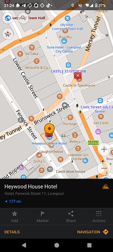
I recently edited a POI: a hotel which has been repossesed by the landlord (which is also the reason for me in getting renewed interest in OSM).
I would expect to be able to edit it, in a way in which history and information about the POI would be retained, and yet the fact that the place is permanently closed would be immediately obvious to any OSM user.
I tried to check with Organic Maps and OsmAnd (the most used and open source Android apps for OSM, afaict), but unfortunately this is how it appears:
(I’m a new user, so I’ll have to add further screenshots in replies to this same post)
(You can also see in the latest screenshot how all of the tags are correctly seen as “disused:” by OsmAnd)
There’s no obvious way to realise, no information displayed about the disused status of this building.
I also tried Mapcomplete (through which I uploaded the pictures on panoramax[1]), and it suggests that if a place is closed, because disused, the place should rather be deleted.
OrganicMaps also suggests just deleting a place completely. I haven’t tried yet, because I’m not sure how easy it’d be to undo, but I’m afraid that would just throw away the history and information about the place.
Checking on openstreetmap.org itself is not much better: I can see the detailed tags with fewer clicks/taps, but the place still appear to exist and is not obviously disused at a first glance.
At the risk of stating the obvious: the ideal situation is that when a user tries to find information (and/or a route) to the disused POI, he would be able to see immediately the disused state, and:
- avoid a wasted trip
- immediately figure out a fallback
Deleting the place altogether would be suboptimal (it would appear missing, people might accidentally re-add it) and confusing it to the user.
And not showing it as disused (the status quo) means that people realise the issue only when they are in front of the property (which is what happened to me and a bunch of other people).
I might try soon to press some of those other buttons in mapcomplete/organicmaps, but otherwise… Is there really no better solution than modifying the name to add a “(permanently closed)” monicker? Getting multiple Android apps to update their UI will of course take time, but is this a well known gap? Has work to address this in the ecosystem already started?
[1] panoramax tags are actually a similar issue as this one: the main openstreetmap.org doesn’t have any special rendering for its id, but if you open the POI in iD editor, you actually get a link to the panoramax image.


