Aligning OSM hiking sections with Wikivoyage

I need to be direct here. The tone and pattern of responses in this thread have been unacceptable. Referring to me as “J Random User,” even indirectly, is disrespectful and dismissive. I have contributed serious work, argued my case clearly, and supported it with concrete, real-world examples. That level of engagement deserves to be met with respect.

The use of “sigh” to dismiss what I said, along with other sarcastic or belittling language, is not appropriate, especially from community moderators. It does not contribute to the discussion. It sends the message that some voices are not welcome unless they already align with entrenched views.

It is particularly troubling that this behavior is coming from moderators, who are expected to set the standard for respectful and constructive dialogue. Instead, what I have encountered here is a consistent pattern of misrepresentation, deflection, and condescension. This does not feel like an open discussion. It feels like an attempt to shut down legitimate input.

I have presented a valid use case that reflects real-world needs and supports better outcomes for both hikers and data users. It deserves serious and honest engagement, not sarcasm and gatekeeping.

Unless you would like to apologize for your disrespectful behavior, I will consider you to be acting in bad faith and not a serious stakeholder in this discussion.
3 Likes

Are you asking me to apologise for the “tone and pattern of responses” rather than their content? I have contradicted you where what you’ve said was, at best, not the whole truth - my assertion that the world is more complex than your experience of it is what led me to suggest a slow and measured approach, which you seem to be resisting.

This is in response to you saying “that is not a quote from me”, responding to this comment, which contained a direct quote of what you said. What you said was untrue - you accusing me of making up something that you had actually said. I would suggest that “sigh” is a rather minor way to respond to that.

I wasn’t. I have edited the comment above to make that clearer.

The only specifics above that I can see are here where you say about the AT (and to be clear I’m directly copying and pasting your text) “Described by state in Wikivoyage as well as most hiking guides. Split up by association in OSM. This may not actually provide a continuous trail with sorted ways (see Waymarked Trails).” The second sentence of that turns out not to be true but is a side-effect of going from relation A to relation B and then back to relation A again. The first sentence is, and a way forward was suggested.

I genuinely don’t think saying “it’s a bit more complicated than that” can be considered “gatekeeping”. To repeat, I (along with other people here) am genuinely trying to help you achieve your goals here. However, that will not be “OSM remodelled in a way that only supports WikiVoyage”; it will be “OSM remodelled in a way that best reflects the real world” If “real world usage” is reflected by WikiVoyage then great - those things then align.

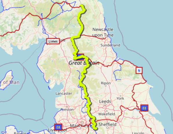
However, it’s entirely possible that what’s on WikiVoyage is one person’s view (and other people may have different ones). As an example, take the Pennine Way (parts of which I’m very familiar with). That is indeed the work of one person, and there are certainly things I wouldn’t say (the Moors Murders) and things that I would that aren’t in (that there’s a signed diversion into Hebden). The route stages somewhat resemble the “official” ones with an extra stop off route in Marsden, but bear little resemblance to the stops I used when I walked the southern bit of it.

Edit: Linked “turns out not to be true” to the relevant post above.

One more thing on Wikivoyage - the Pennine Way article could really benefit from a map showing the actual route. Instead there are a few numbered points on some sort of road map?

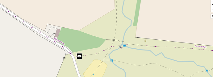
Edited to add a couple of examples. Here’s one way of doing it (Waymarked Trails)

Here’s another (one of mine):

The vector data used by that second one has LDPs at vector zoom 12 and could absolutely make them much more obvious at lower zoom levels.

Thank you for the clarification, but this response confirms the concerns I raised.

The issue is not disagreement. It is the repeated pattern of belittling tone, misrepresentation, and deflection. Reframing those concerns as me being resistant to complexity or misreading quotes is not helpful. It avoids taking responsibility and shifts the burden of tone and clarity entirely onto me, despite a long thread in which I have remained constructive and direct.

You may claim to be helping, but the cumulative effect of your responses has been discouraging, dismissive, and, at times, condescending. That includes language like “sigh,” referring to contributions as equivalent to “J Random User,” and repeatedly positioning your views as inherently more valid or informed.

You are welcome to disagree with the structure or use case I am proposing. That is normal and expected. But doing so while disregarding basic respect and good faith engagement is not appropriate, especially from a moderator.

At this point, I will not continue this exchange. I will focus my energy on working with those who are able to engage respectfully and collaboratively.

2 Likes

I write a lot of stage-based guides to outdoor routes whose geometry is ultimately stored in OSM as route relations (here’s a few randomly selected ones: 1, 2, 3, 4, 5, 6… at least one of which has been shamelessly ripped off by Komoot :roll_eyes:)

I’m not aware of any advantages of OSM deciding on a canonical set of stages and it’s never been anything I’ve wished for. The organisations and sites you cite will have, as I do, their own systems and tech for creating stages according to their own editorial decisions.

From this thread, it sounds like Wikivoyage maybe doesn’t have that degree of technical sophistication, but that’s a Wikivoyage problem rather than an OSM problem. As ever, our most valuable commodity is mappers, so we optimise for the mapper rather than the data consumer.

6 Likes

Thanks for the thoughtful message.

I understand that these organizations and platforms often define trail sections through their own editorial processes. However, when I look at the most commonly hiked long-distance trails, it appears that OSM mappers have already, in practice, split many of them into sections that align closely with what is useful to hikers. The only major exceptions seem to be the trails discussed in this thread.

At this point, the only trail where there seems to be significant uncertainty about whether this kind of split should be applied is the Appalachian Trail. Even there, the discussion among mappers shows that there is no strong consensus on what the current sections should be. If a trail is going to be split, and multiple approaches are equally valid, why not choose the one that reflects how hikers actually use the trail?

There also seems to be some confusion about the term “canonical sections.” I am not advocating for a fixed, universal standard. I am advocating for splits that are meaningful from a hiker’s perspective. These do not need to match Wikivoyage, and I am happy to adjust Wikivoyage content when needed. Nor do they need to be definitive, but I believe a natural convergence will happen over time, just as we see in published hiking guides.

All I am advocating for is that there is a split, and that it serves a purpose for hikers. This is already the case for the vast majority of long-distance trails in OSM, and we are very close to seeing it completed across the board.

At the end of the day, this is not about remaking OSM to suit one project. It is about recognizing that the approach already used on most trails, splitting them into meaningful segments, has proven to be effective. I am simply advocating for applying that same consistency where it has not yet been done.

Wikivoyage guides are included in the OsmAnd app, which means they can be used alongside OSM data. Maintaining alignment between the guides and the actual OSM routes benefits both projects and creates a more coherent experience for users.

Now consider this. Imagine you have a dataset that already contains almost everything you need in the correct format, except for one outlier that is structured differently. Do you create an entirely new system and integration just to handle that single exception, or do you adjust the one outlier to match the existing structure?

If it’s an issue of the Appalachian Trail being “one outlier” then I’d suggest addressing it on the level of the Appalachian Trail.

You’ve posted in the “general” category here and so you’re inevitably going to get people replying about their experiences with other long-distance routes across the world. From previous discussions on this site, American long-distance hikes seem to be quite different beasts from what many of the rest of us are used to.

I did a bit of a cursory literature search in Blackwells yesterday[1] for A Well-Known European Hiking Trail and there is no substantive agreement between the stages chosen by different guidebooks, let alone what’s mapped in OSM. Personally, the last time I did a long-distance walk was the Pembrokeshire Coast Path which doesn’t have a single set of stages either - right now it’s mapped in OSM as one single relation, which is almost certainly as it should be.

But changing how the Appalachian Trail is mapped doesn’t require a debate about worldwide tagging practices, it just requires changing how the Appalachian Trail is mapped.

(Footnote: Just in case you’re not aware, OsmAnd is not an official, or in any other way privileged, OpenStreetMap app. It’s just one of thousands of apps as well as being JOSM’s prime challenger in the OSM Startled Warthog UI Championship. If it were announced today then OSMF would presumably come down on them like a ton of bricks for trademark issues, but because it has a fair degree of traction no-one wants to grasp that particular warthog-shaped nettle. You very possibly know this already but it confuses the heck out of a lot of people, so I figured it was worth mentioning.)


  1. They use OSM in their store finder! ↩︎

2 Likes

Thanks for the message.

I believe this thread is correctly categorized, as I am working on this topic across several long-distance hiking trails. Focusing on the Appalachian Trail is exactly the takeaway I had from this discussion, and I agree that it makes sense to address it at that level.

I appreciate the clarification on OsmAnd. My point was simply that Wikivoyage content appears there, and having the guide text and route data aligned improves the experience for end users, regardless of the platform.

Every UK long distance route I have looked at on Wikivoyage tells me to buy a set of OS maps, hardly promoting Opendata or OSM.

I am a Ramblers walk leader with 30+ years of experience.

On thing I learned very early on is not to try walking using a text description. Sit down and transpose the route to a map, in the early days that was OS but these days it will be an OSM based map.

Reality is very few people using the paths which make up long distance routes are walking the long distance route but are out walking the dog or just making up a circlar route using other paths to complete the circuit

I have walked most of my local long distance route, Shropshire Way which is 325km, over a number of Saturdays by breaking it up at points where buses or trains are within reach.

Long distance routes have to visit certain honeypot locations which means at some points a path will be a member of several routes. The Shropshire Way obviously must cross the world famous Iron Bridge.

2 Likes

Every UK long distance route I have looked at on Wikivoyage tells me to buy a set of OS maps, hardly promoting Opendata or OSM.

I would guess the OS maps mentioned are paper maps. Most wilderness trail articles recommend carrying paper maps, as this is the general advice for hiking in remote areas. In practice, almost everyone uses digital maps now, and paper maps are more of a backup in case something fails.

I would like to see Wikivoyage refer to OSM much more. My frustration around low OSM usage for hiking trails was one of my main reasons for editing Wikivoyage articles. It’s also the main reason for this post/topic.

On thing I learned very early on is not to try walking using a text description. Sit down and transpose the route to a map, in the early days that was OS but these days it will be an OSM based map.

I think the two can inform each other. I’ve hardly seen anyone carry paper maps. I’ve seen plenty of people use physical guidebooks. I find that writing something down often helps a lot in thinking around a problem in general.

I’d like to see more Wikivoyage users/editors contribute to OSM as well, which is something that could happen if people notice the POIs don’t align with the actual trail, or that an alternative route description is off.

Reality is very few people using the paths which make up long distance routes are walking the long distance route but are out walking the dog or just making up a circlar route using other paths to complete the circuit

In my experience, many people walk only sections of hiking trails, usually well-defined segments. For example, on the West Highland Way, most people choose a section that begins and ends at accessible points, such as towns.

I can’t say for certain, but I think most people hiked the whole thing, rather than section-hike it. My experience is similar for the most popular long-distance paths. People choose to hike the entire trail. I guess it would depend on the popularity to an extent. This is off-topic though.

I hadn’t seen this. Thanks for the comment! At the moment, for the Appalachian Trail, the operators are no longer individual relations, they’re captured in tags as well. This tag doesn’t seem to get much use, and in reality, most mappers choose to map stages as separate relations. It would be good to standardise this.

Thanks for posting in the Phabricator issue! The more the merrier. I hope this gives them some additional incentives to look into this.

I’ve taken some time to organise my thoughts.

I believe it would be valuable to have a standard for indicating stages on hiking trails. This is important information. However, I find the terms “canonical stages” or “official stages” somewhat misleading.

No stage is truly canonical. There’s no requirement to hike a trail in specific segments. Even if an official body proposes stages, they aren’t set in stone. Many guides offer alternate breakdowns. That said, over time, most hiking guides tend to converge around practical entry and exit points and reasonable daily distances.

If stages were only allowed when they are “canonical,” then no trail would qualify, because such canon does not really exist.

And yet, stages are widely used. This suggests they are genuinely useful. We should treat this information seriously rather than dismiss it. If there were no need or desire for stages, why are most hiking routes on OSM mapped with them? Arguing against stage information at this point feels like arguing against the practical work and interests of OSM contributors.

It would be worthwhile to consider establishing a consistent standard for how to record this information. In OSM, the most common approach is to represent stages as separate relations. This is clearly visible in examples from Sweden, Norway, and many other places.

To me, this seems to be the de facto standard, and I support maintaining that consistency. So I would stand by my original position.

Perhaps the resistance mostly stems from standardising in itself. In any case, there is an underlying question here that hasn’t been addressed.

As someone unfamiliar with long-distance hiking, I wonder: Isn’t the concept of pre-determined stages perhaps something old-fashioned that we’re carrying over from times of guidebooks that, because of printing technology, could not be personalised?

Would you not expect to have the entirety of the trail at your perusal, together with any pertinent information like locations of camp sites, hotels, railway stations, or whatever is relevant for your personal way of tackling the trail, and then would you not want to have some form of app or web site that helps you segment the trail in some way that is appropriate for your circumstances and your hiking speed and perhaps how much daylight there is when you are going and so on?

Should we perhaps limit ourselves, in OSM, to recording the basic information that will make such personal segmentation possible, rather than attempt to provide some form of pre-determined segments that we find practical? And endeavour to record faithfully the details that enable someone to find their personal best segmentation, rather than provide a canned one?

3 Likes

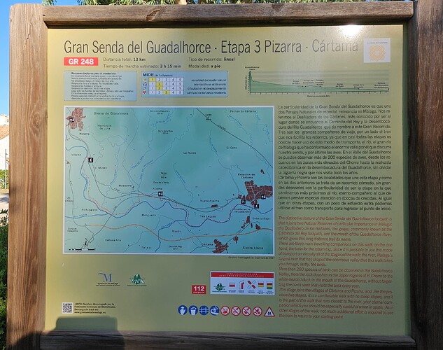
Some routes do have clearly defined official stages. It seems clear to me that the trailhead in this photo is the canonical starting point of Stage 3 of the GR 248. The stages are defined by the same authority as the route itself and are verifiable on the ground, so they are just as official as the overall route. They even have convenient numbers that fit the stage= tag. It would be very confusing to hikers to map a different set of stages in OSM.

Of course I am aware that many routes are not like this. I think some of the resistance you perceive was because you initially seemed reluctant to approach such routes on a case by case basis.

I agree that where stages are mapped, the standard approach is to use a relation for each stage. But I’m not sure anyone has suggested otherwise. Is there another way?

Funnily enough I have the opposite perception. At least near where I live in the south of Spain, older routes tend to be waymarked as a single long route. Routes developed in the last 10-15 years have a much more systematic approach to stages, as illustrated in my previous post, and are typically broken into stages that could be hiked within a day. When I hike parts of these trails myself, I don’t always follow the suggested stages, but because they are prominent on the ground I still tend to orient myself by them, e.g. I might plan to walk from the middle of stage 3 to the middle of stage 4. So having these stages in OSM has been very useful to me.

So, I agree that we should try to record the information that would help people to plan their own itineraries, but I also think that stage information is very useful where it reflects the way the trail is presented on the ground.

I don’t really have strong feelings one way or the other for trails that don’t have identifiable sections on the ground. But I wonder if we should have some way to distinguish these, so that hikers on those trails won’t expect to see Stage 23 in OSM reflected in signage for Stage 23 on the trail.

2 Likes

OSM data is built step by step by various controbutors, and standardisation of high level or more abstract concepts is not easy: sometimes there’s several point of view on how to model a route, each of which have good arguments.
I join @woodpeck interrogations and if there’s no clear cut stages for a long distance trail, I don’t think we can make a proper editor’s choice in OSM: to many editors, no single editor-in-chief.
This is where websites like Wikivoyage have a role to play, in choosing how they will present a trail and crunch it in stages as they see fit. But this means they have to digest the data, maybe programmatically and possibly from other arbitrary inputs to fit each stage under one day if that is they want to display, or else.

4 Likes

We use a hierarchical model for route relations, where the lowest level member relations contain the ways of the route. Technically, it doesn’t matter if the member relations are real world stages. So it’s a mapper’s choice if and how to cut up the route in sections. Some mappers/communities choose to map a long route as one relation; others cut the route up in regional sections; others follow a more or less official division in stages.

Route providers usually provide daily stages, which are usually not indicated on the route IRL. Stages in a route guide are usually equal to digital information and downloadable gps-traces. If there is stage marking, it makes sense to use the marked stages to section the route relation in OSM.

Even without stage markings IRL, it still makes sense to follow the published daily stages, one member relation per daily stage, if these stages have specific stage information you want to convey to application users. Some of this may be purely additional, such as stage numbers, other information may have ground truth, such as length, start location name, end location name.

Downside: handling the relation hierarchy requires non-trivial processing. Also, many (super)route relations are discontinous collections of variants, especially international routes. Very few applications (just the one, I think) handle the route hierarchy properly: rendering is relatively easy, but for e.g. custom stage planning there is nothing AFAIK.

I know only one application for custom stage planning by end users: longdistancepaths.eu. It is based on OSM data, it presents the longdistance route as a whole, then allows the user to cut out and store custom stages, based on PT-stops, city names, hotels and the like. Custom stages can be exported as gpx and kml.

Anyway, I think that’s where we should be going, and the data model supports it. Aligning the sections with an external source is fine with me, it’s a mapper’s decision.

1 Like

That’s a fair point. If stages are clearly marked on the ground, then they absolutely exist and should be mapped in OSM. In those cases, they’re arguably not just “canonical” suggestions, they’re part of the physical infrastructure, and mapping them benefits everyone.

When I reviewed long-distance trails in Sweden and Norway, I noticed that in most cases there’s no on-the-ground signage, yet stages are still mapped. That inconsistency highlights the need for clarity.

What I’ve gathered from several users here is the idea that “mappers can do what they want.” As a mapper, I find that a bit confusing, especially given how close we already are to a de facto standard. It seems contradictory to say we should handle everything case by case while also defending an “anything goes” approach. If all interpretations are equally valid, consensus will be difficult unless we are willing to step back and consider the broader picture.