Dear friends and contributors from the UK and the wider European region,
My nickname is dreamy, and I’m an active contributor from the East Asian community.
There seems to be some ongoing confusion around the concept and tagging of unclassified roads, so I’d like to begin by asking the UK community directly for your insights and clarification.
As definitions and legal classifications from the UK may not be applicable elsewhere, I’d prefer to set aside legal or administrative aspects for now and focus solely on a few visible, outward characteristics that might help identify such roads in mapping practice.
Unfortunately, I’ve never had the chance to visit the UK, though I have come across roads in various parts of Europe that I believe might correspond to what OpenStreetMap refers to as unclassified roads.
Based on that experience, and after reading several documents available online, I’ve attempted to summarise my understanding of what unclassified roads typically look like.
I would be very grateful if you could let me know whether the following points are reasonably accurate or if I’ve misunderstood anything. Additionally, if there are any visual or structural features that I may have overlooked, I would sincerely appreciate your guidance.
- They are generally surfaced with asphalt concrete. Since this material is not typically used in informal or private settings, I interpret its presence as a sign that some level of public authority or administration was involved.
- They usually have no road markings, or in some cases, only a simple centreline (often a white solid line) for convenience. Edge lines are typically absent. (Some may have no markings at all.)
- There is usually little in the way of road signage, particularly for traffic control or guidance. However, basic signs may exist at junctions or along longer stretches of road to assist with navigation.
- They serve to connect villages or districts and are not primarily intended as farm tracks.
These are the general criteria I currently use to identify an unclassified road.
Would you say this description reflects the typical characteristics of such roads in the UK?
And are there any other visual indicators or features you would recommend looking out for when tagging unclassified roads?
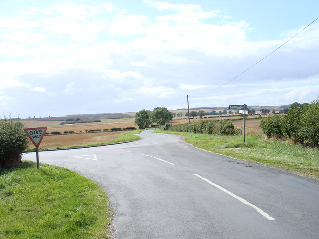
This image is probably the most typical example of what I would recognise as an unclassified road.